Uncategorized
Low Level Living Leads to Lots of Liquid
 January 24, 2008
A note of concern from Joan Lechtenberg on E. Nature Drive in Boise could be a harbinger of the coming spring runoff which will undoubtedly be robust as the result of what appears to be a “normal” snowpack.
She called the office of Team Dave at City Hall noting those pesky developers are dumping fill dirt along the river opposite her place. Those on the high ground tend to have the advantage whether it is war or flooding and she doesn’t want to end up on the low side.
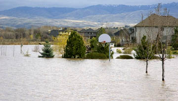
The flash flood and stream bank collapse along Dry Creek in Eagle caused flooding two years ago. With about 10 years of below average snow years on record, there are bunches of newbies in McMansions along the Boise River and various streams who have never experienced a “wet spring.” They would be wise to invest NOW in flood insurance.
The GUARDIAN echoes the concerns of Ms. Lechtenberg and suggests any terrain altering intrusions–including footpaths and levies–be removed immediately. She identified areas along the river in the east end of Boise near the Bown Crossing development.
Ironically, the high end homes seem to be in the low level locations along the river. The area has been in the flood plain forever, but today there is no telling where the high water will go due to stream alterations, dikes, and natural filling of deep spots due to many years of low runoff.
Growthophobes will tell you those living in flood plains deserve to get soaked–and not just by the mortgage company. Not very neighborly, but they have a point about taking your chances when you live in the lowlands. Experience tells us dikes along the river merely increase the velocity of the water and send it downstream to flood someone else.
To insure more advertising-free Boise Guardian news, please consider financial support.
Comments & Discussion
Comments are closed for this post.

Jan 24, 2008, 11:26 pm
Would that be Mrs. Lechtenberg of the famous Lechtenberg Development Corporation? Because, if not, someone should tell the poor lady she has been had. EVERYONE knows that Team Dave only responds to those big, fancy developers.
Jan 25, 2008, 12:41 am
And let us remember the last flooding in Eagle when the expensive homes got some kind of help but the mobile home families in west Eagle Island got nothing – they would have flooded out except that the acting governor Risch called in the National Guard. I really hate to say that I held him in great esteem for that action. I think Gov. Otter would tell them to eat cake. But I could be wrong. If I am in error please bring me back to reality.
Jan 25, 2008, 7:14 am
It was thier choice to build in the flood plains. Let them figure it out themselves. They have blocked the public cutting off access to the river, diverted the river, hurt the wild life, generally distroy the beauty of the river. Let’s not spend tax payers money to protect these properties.
Neighborly? well just try getting to the river from these properties and you will see neighborly.
Jan 25, 2008, 10:10 am
I agree that bank alterations should be kept to a minimum as it can affect people up and down stream. But I don’t feel for anyone that is endanger of the rising waters, as we all make choices in life-some wise and some not so wise. Here is a history of flooding in Ada County from mid 1800’s to current day. Major flooding has not happened since lucky Peak was built. The flows prior to that were amazing- one river from the Bench to the Foothills.
http://www.bhs.idaho.gov/local/counties/ada_history.htm
Jan 25, 2008, 11:07 am
I think there is a simple explanation for what Mrs. Lechtenburg is seeing. About 10 acres along the river north of Barber Park are being converted to a wetland and pathways. There may be some fill dirt for the paths, but the big piles of dirt are what has been excavated. The result will be an area of land that will flood – by design at high water – and it will function as a wetland.
EDITOR NOTE–Hope you are 64.07% correct. Pretty hard for anyone to decipher much with snow cover, but thanks for your info. We assume you are an insider. If you can get anyone in “authority” to weigh in it would be great.
Jan 25, 2008, 1:18 pm
Can you say EAST PARKCENTER BRIDGE? Maybe she ought to move now before they really get going on construction.
Jan 25, 2008, 1:39 pm
If you are going to invest huge amouns of hard earned cash for a home near a stream, river, or body of water it is in your best iterest to take note via the FEMA maps where the 100 year flood line is.
It is all part of the due diligence in this kind of a deal. While it may look inviting to live near a stream or river you have to go in with eyes wide open. Those that built in a flood plain chose to believe that floods don’t happen. And those of us who have been around a while know just how bad the flood of the 1984/85 run off season was. The high water marks are still on the bridge pilings and abutments all along every waterway.
Jan 25, 2008, 3:29 pm
I bet Gov. Otter would bail them out as well. His house sits in the flood plain as well.
Jan 25, 2008, 4:14 pm
Dave – I’m blessed to have the perspective of an old-timer.
I can remember as a young child, accompanying my dad to friends’ houses in Boise’s east end (McKinley, Avenue E, etc.) and playing in the recending waters while he helped shovel out flooded basements. (Long before most of the development along the river. People were discouraged from building there, back in the day.) I can remember Fort Boise underwater, and sandbags laid along Broadway Avenue all the way to the river, to divert the torrent.
I had a friend who lived just off Eagle Road, back when it was a sleepy little 2-lane. Every spring he bermed up his property as best he could with sandbags and visqueen. Help wasn’t asked for or offered. (He sold his property 10 years or so ago for $$$ – there are million-dollar houses on it now.)
More recently, I’ve ridden my bicycle along stretches of the Greenbelt where the water was hub-deep. In the springtime, of course.
Yep – 2 years ago was “normal.” Wait ’til all the newcomers see an above-average water year. (It’s not a question of “if,” but rather “when.”)
I’m only human, and I have to confess I’ll feel a bit of schadenfreude.
(For you non-German-library-types, that’s “enjoyment obtained from the troubles of others.”)
It would indeed be interesting to see if Governor Otter responded in some official way, since he has a storied reputation as an “unauthorized wetlands alterer,” out there on the ranch.
Jan 25, 2008, 8:26 pm
Mr Guardian
64.07% is correct. They even have a sign up on the bike path by Eckert Bridge. My understanding it the dirt has been sold and will be gone shortly.
Long term this will help the rich folks in the Wood Duck area. WOW Mr Guardian, you couldn’t see the piles of dirt??? Maybe you should take another plane ride… or better yet drive across Eckert Bridge.
If Joan Lechtenberg is concerned about the dirt, just wait until they start pounding pilings for the new bridge In March. I hope she doesn’t takes naps in the day
http://www.achd.ada.id.us/Projects/PublicProject.aspx?ProjectID=27
Jan 26, 2008, 6:23 pm
Having been born, raised and had raised my own family in this city of Boise I must say that along with everyone else, I love the Boise River. It rubs me the wrong way when out of state newbies want to turn it into one of the cement “rivers” of LA.
Rivers are a living thing. They change with the weather. Their banks move. Don’t like it…. please move further from it. It’s gonna move – if not this spring, then maybe next – but it WILL move. And that is why I live a respectable distance from it’s banks.
It’s great! Go River!!!!
Jan 27, 2008, 12:52 pm
Just reminder … the flood along Dry Creek in Eagle that closed a part of Floating Feather and Eagle Road was caused by a tree branch that snagged on a wire fence that was strung across the drainage.
Apparently, a local homeowner owned property on both sides of the drainage. He didn’t like people in the new subdivision next door having potential access to his property so the brain-trust strung a 3-wire fence over the drainage to completely enclose his property. During a storm, a tree branch fell and was swept downstream. It caught on the lower wire and started to collect debris that was also travelling downstream. It didn’t take long before a dam developed and flooding resulted. The flood waters compromised some of the berming up and down the drainage. It didn’t take much to completely wash out part of Eagle Rd which was built on sand in that area.
City officials will tell you their flood modification procedures worked. The areas in the Brookwood subdivision that were set aside for flood water collection filled. Landscaping and a few basketball courts went assunder but no homes flooded. But then again, it was only one tree branch snag and there were a couple of farms and larger properties that were able to absorb some of the water. Had the area been more developed or more treefall – or heaven forbid, more water – the story could have been much different.
ANY OF US could experience flooding. I live on a butte and could have flood water flow across my property if there was a problem with the neighbohood irrigation system which still flows in an open ditch. A fallen tree, a ill-placed beaver dam, an abundance of dirt or yard debris or even a car going off the road could cause damming that could lead to water going the wrong direction at the wrong time.
Feb 1, 2008, 5:29 pm
Just got word from a friend in Seattle and I was blown away by the prices of houseboats on Lake Union. I think Ada County ought to raise the taxes on those McMansions in flood prone Eagle. Lake front property seems to be in high demand everywhere even in these days of realestate deflation. Glad God likes us and is busy making more of it. There seems to be plenty of rich people to buy it up.