Uncategorized
Wild Fires Rage East Of Boise
 August 11, 2013
The following is an unedited press release from the U.S. Forest Service
- Extreme Fire Behavior Is Predicted for Area Fires Sunday
Boise, ID – Firefighters endured another long night on the firelines working to keep both the Elk and Pony Complexes at bay.
The plume-dominated Elk Complex is now estimated at 80,365 and 0% contained. Both ground and air resources employed strategies and tactics to battle the fire east of Prairie towards the landing strip. Late yesterday, the fire moved into the Lester and Fall Creek.
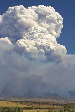
Pyrocumulus cloud tops wildfire east of Boise near Mayfield.
This morning it is reported that the lodge in Fall Creek and approximately 20 structures have not been damaged by the fire, but it is believed there is structure loss further up the drainage. The Lester Creek Guard Station has not been damaged. Fire officials hope to gain access today to assess the situation if conditions allow.
A 600 acre spot fire occurred late yesterday on the north side of the South Fork Boise River in the Rock Creek drainage. This is a concern as the fire may move north out of the river corridor and effect areas west of Prairie.
The Elmore County Sheriff’s Department as of this morning is notifying residents from Johnson Bridge (about half way between Pine and Featherville) south to the junction of the Pine/Featherville Road and Highway 20 that they need to leave the area. Campers are also currently being requested to leave. The fire situation and potential for growth will be evaluated as the day progresses regarding further evacuation needs. The Sheriff’s office has established a road block at the Pine/Featherville Road and Highway 20 junction.
Access to the Falls Creek area is restricted
A public meeting is scheduled in Pine at the Pine Senior Center tonight at 6 PM.
The Pony Complex experienced extreme fire behavior yesterday and the fire is now estimated at 100,090 and is 10% contained. Crews conducted burnout operations in and around dispersed residences and ranches in an attempt to stop the forward progression of the fire to the west near the community of Mayfield. Currently, the fire has reached the Blacks Creek Road.
The Danskin Lookout was evacuated and retardant was used to protect the structure. An unknown amount of cows and sheep, that are associated with Forest Service allotments, are missing/unaccounted.
A public meeting is scheduled for this evening at 6 PM in Mountain Home at the Elk’s Lodge. Fire officials from the Elk Complex also will be present at the meeting to provide an update.
Incident information for both fires can be viewed at www.inciweb.org
The following road closures continue to be place:
Blacks Creek Road off I-84 at the Mayfield Road junction
Indian Creek Road off I-84 at exit 71
Anderson Ranch Dam south on the Dixie Creek Cut-off to Hwy 20
Prairie Road/Cow Creek Road heading north from Hwy 20
Forest Road 128 from Pine
Due to extreme fire behavior, the following area evacuations have been issued by the Elmore County sheriff’s office:
The community of Prairie and Mayfield (which includes Regina, Indian Creek and Baseline);
Anderson Dam Reservoir up Fall Creek Road to Ice Springs Campground then east to Lester Creek Guard Station;
Danskin fire lookout.
The American Red Cross has opened an evacuation shelter at the Good Council Hall in Mt. Home for any residents that have been displaced due to the fires.
The Boise National Forest has initiated a large area closure that extends roughly from the Pine/Featherville road on the east; Forest Road172 and the William Pogue Trail to the north; the Middle Fork of the Boise River to Arrowrock Reservoir; then extending south along the forest boundary to the north side of Anderson Ranch Reservoir. Additionally, the Trinity Lakes Recreation area is closed.
The Middle Fork of the Boise River Road is open.
For specific information and a map, please visit http://inciweb.org/incident/3616/.
Other Fires burning:
The Idaho Department of Lands (IDL) is managing multiple fires within their jurisdiction:
The Pilot Fire has burned approximately 11 acres and is 10 miles east of Garden Valley;
The Missouri Fire is ¼ acre in size and located 2 miles North of Pioneerville
The Clear Fire is a 1/10 acre in size and located 2 miles Northeast of Pioneerville
The Jackson Fire is 1 acre in size and located 5 miles Northeast of Placerville
The Boise National Forest demobed seven lighting caused fires and has two fires that have not yet reached full containment:
The Casner Fire is 1 acre in size and located 8 miles southeast of Deadwood Reservoir
The Danskin is 2/10 acre in size and located is 6 miles east of Garden Valley
The BLM Boise District responded the following fire(s):
The 50 acre Regina Fire located south of I-84 near the Stage Stop and Indian Creek Reservoir (Boise City Fire Department assisted with fire suppression activities)
Stage I fire restrictions remain in effect including using a campfire outside of an agency designated recreation site until further notice. For more information, please visit www.blm.gov/id.
There is a Fire Information Center established in Boise which will be staffed from 7 AM to 7 PM., and the center can be contacted at 208-384-3266. Personnel at the center will be able to provide general information on large fires in the area.
For more information on Wildfire Smoke and your Health please visit: http://healthandwelfare.idaho.gov/Health/EnvironmentalHealth/WildfireSmoke/tabid/2172/Default.aspx
To insure more advertising-free Boise Guardian news, please consider financial support.

Comments & Discussion
Comments are closed for this post.
Comments are closed.