City Government
Boise Council Knows Better Than Fed Experts
 December 1, 2016
Once again Boise City Councilors have continued the policy of “we know better.” This time it is with the Government of the United States of America’s flood experts.
Seems the Feds have redrawn the flood plain map along the Boise river to include additional acres of land subject to a “100 year flood.” That term means there is a 1% chance of a flood each year. STATESMAN reporter Sven Berg has a big take on the issue in Thursday’s paper.
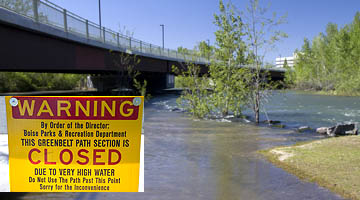
At issue is flood insurance–issued by the Feds for homes along the river. They will not issue the insurance within the zone unless the structures meet certain grade requirements. Lenders will not loan money without the insurance. Of course, the big elephant in the room is developers who stand to lose out on potential huge sums of cash for construction of subdivisions. The developments would be all along the river, not just within the city of Boise.
To make their case, Boise Councilors authorized their own study not to exceed $25,000. The City is at odds with the Feds and since the expenditure is under $25,000 there is no need to get bids, hence the study contract can go to whomever the city selects along with what we suggest will be a pre-determined outcome.
One factor no one has mentioned is the giant “sponge” north of the river–mainly the foothills–that has been effectively “wrapped in plastic film” through rooftops, driveways, and street surfaces…the only place for runoff to go is the river. So despite the Lucky Peak Dam, there is a risk, however slight, of flooding in lowland areas.
Regardless of how one feels about the Feds and FEMA, it seems absurd that a $25,000 study by Boise would be scientifically more accurate than that of the U.S. Government. AND, we get to pay twice.
These political negotiations over scientific data are nothing new. Here is what we posted in the GUARDIAN 10 years ago.
To insure more advertising-free Boise Guardian news, please consider financial support.
Comments & Discussion
Comments are closed for this post.

Dec 1, 2016, 12:32 pm
Careful…last time you played in river, you got delisted from press releases. https://boiseguardian.com/2010/08/11/round-2-of-guardian-de-listed-by-boise-pd/
I can tell you that water doesn’t care about politics or who thinks they are right. It will always seek its’ own path.
Dec 1, 2016, 1:06 pm
Boise City Council believes the consultants paid by developers more than their own common sense.
Dec 1, 2016, 4:09 pm
“a pre-determined outcome”
Isn’t that what we ALL want in life?
Maybe the question is, WHY the fed determined different flood lines.
Did our topography change?
What changed?
A 100 year flood – precision is not going to matter. I have my boat ready!
Dec 1, 2016, 8:04 pm
Probably a minor consideration but will it change the status of the proposed CWI Boise campus?
Dec 2, 2016, 7:10 am
Berg did an excellent job in his article. One sentence stands out as true: “And while we all know what a flood plain looks like, putting precise lines on a map takes a tricky combination of data and guesswork.” That isn’t to say that Boise and GC are correct in challenging, but it does indicate that it’s not a precise analysis–meaning it’s open to revision. Also, why is it that in this case we have “Fed experts,” but when it comes to climate change, or sage grouse habitat, or forest management the feds are idiots?
Dec 2, 2016, 9:10 am
If Lucky Peak breaks it won’t matter where you live in Boise….Except for the foothill folks and the Bench.
Dec 2, 2016, 3:02 pm
Interesting article! And, it’s curious that Boise is jumping in – looks like the vast majority of affected acreage is west of the Boise city limits. (Although I’m sure Team Dave DREAMS of the day when it’s all part of Boise!)
I’ve been around to personally observe almost two-thirds of those hundred years. Some notes for the newbies:
1) Lucky Peak Dam has NEVER breached! (And is unlikely to.) But the Army Corps of Engineers WILL release a lot of water if need be… that’s why it has never breached.
2) The trend recently is for lower-than-average precipitation, and thus relatively low river flows, even in the springtime. However, even if you’ve lived here for only a few years, you should recall stretches of the Greenbelt underwater and folks in their McMansions downstream getting agitated as water rose into their backyards.
I know a guy who used to live in a tiny house on Eagle Island – almost every year he bermed-and-tarped around his house to keep the river out, and had 2-by-12 walkways so his irrigation boots wouldn’t get too wet. Some developer bought him out and slapped up some McMansions on the very spot. Berms and tarps are NOT part of the new occupants’ imagined lifestyle!
3) Water that arrives from a direction other then the Boise River is NOT regulated. I can remember shoveling mud out of basements in east Boise as a young child. (The mud was carried by heavy rains, from the foothills north of town. No dam to stem the flow.) And a few years later I played in floodwater that overflowed the dikes north of Fort Boise, and covered Fort Boise, and was directed down Broadway Avenue with sandbags.
Living on the beach, or in the river bottoms, entails some risk. Lenders don’t want to assume that risk, preferring to pass it on to the beneficiaries of that waterfront lifestyle.
Dec 2, 2016, 6:17 pm
They needed to redraw the lines to increase the base of people paying into the flood insurance fund. Floods from the past several years have depleated the fund.